Recap.

Okay boys and girls… Listen up. I’ve come to a realization that for your learning sake we should go over my trip (generally of course) so you can remember the different sorts of boundaries. 

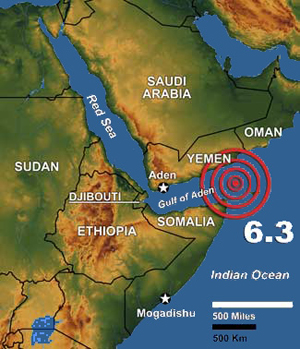
1st stop Aden Ridge: Divergent Tectonic Plate Boundary. Two plates moving away from each other and then the mantle fills and creates (in this case) underwater mountains. 

2nd stop San Andreas Fault Zone: Transform Boundary. Two plates grind against each other and can create high magnitude earthquakes. 

3rd stop Tonga Trench: Subduction Convergence Boundary: Two plates run into each other and the denser one goes under the other and creates mountains (or volcanoes) and deep trenches. 

4th stop Himalayas: Collision Convergence Boundary: Two plates run into each other and they both go up wards creating a mountain range or volcanoes. 

I hope this gave you some helpful info without boring you too much. Hopefully I’ll be back for another trip and update you on my new marriage but no promises. I’d like to thank all my fans and fellow badgers, nerds, and cool beings. Shout out to Peggy for being the most beautiful fiancé I could ever ask for and all my other supporters. Also to my teacher too! You know who you are…

Love forever and ever,

FUDGEY BADGER

Himalayas Collision Convergent Boundary!

Holy Moly! Last stop for this young badger… I’m super tired because we just took some horses up one of the mountains North of Nepal in the Himilayan mountains! It was super cold and my fur was barely thick enough to keep me warm. But me and and Peggy cuddled to keep warm so we just ignored the horses we rode up. They didn’t mind much. But boy my butt hurts! These mountains are so tall all because of the stupid collision convergent boundary. The Himalayas are on continental-continental convergent boundaries. Two plates, the Eurasian Plate and the Australian-Indian Plate, are colliding into each other and then push up and create mountains. Really steep mountains…. And they are super prone to high magnitude earthquakes. They pose a huge threat to the population around them and can be killers. Not many volcanoes, thank goodness. Almost fell off a horse but all is well with Fudgey! Hope ya’ll are doing great.

Love forever,

Fudgey.

http://static.ddmcdn.com/gif/willow/the-himalayas0.gifImage

http://legacy.earlham.edu/~pinema/pics/Convergence%20map.gifImage

Latitude:  28°30’51.28″N

Longitude:  83°48’45.20″E

More on Trudge..

So this Trudge dude struts in on his four paws thinking he’s super cool and I saw Peggy.. She was like super into him still but we’re getting married!! So while we were swimming I mightttt have gotten a little passive aggressive and shoved him underwater so he got poked by a pufferfish… Tell me, too mean? Anyway Peggy thought I was being super tough and badgerly so afterwards we went into this cave and had a romantic dinner. Delicious rattle snake seasoned with spiders and iguana scales… Yum yum… Well I showed Trudge who’s boss and got rewarded too 😀

http://www.fishingtarget.com/foto/pufferfish-3.jpgImage

Subduction Convergent Boundary

Hello again…. CREEPY ENTRANCE… any who,

After traveling to California I decided I just had to go somewhere in the southern hemisphere. Peggy and I met up with her ex boyfriend named Trudge (awkward…more on that later) and we swam all the way out to the Tonga Trench! It was just off the shore of South Eastern Australia! There were wallabies and kangaroos and crocs, mate. We saw sharks and pufferfish too but of course, the beautiful motehr earth distracted me again…The Australian plate and Pacific plates are running into eachother but the denser Pacific Plate is subducting (going below) under the Australian Plate. That forms the Tonga Trench! But it also creates paralel islands and helped create the eastern side of New Zealand. Pretty interesting I know… The islands west of the trench are volcanic and frequently have earthquakes do to the grinding of plates and mantel coming up. Anyways it was a really cool stop and I hope you learned something about trenches…

Image

photo: http://i35.tinypic.com/1z3a4ib.jpg

Latitude: 20° 0’2.59″S

Longitude: 172°59’59.66″W

Transform Boundary!

This was our second stop and we had a great time visiting the San Andreas Fault Zone! California man!!! There weren’t many surfer dudes because I suspect they were out in the ocean but that didn’t ruin my fun! This is one of the many transform boundary areas that occur on land. A transform boundary is when the two plates (in this case the Pacific Plate and the North American Plate) grind against each other but not quite running straight into each other. The Pacific Plate is moving slowly to the northwest while all land east of the fault is moving southwest creating a fault. San Andreas Fault Zone has had some notable earthquakes and the most recent one being in 2004 was measured at a 6.0. (Pretty darn big, thankfully I wasn’t alive back then..) As the two plates sort of “crash” (a very slow-mo crash) the plates get pushed up and start to look like this:

Latitude: 35° 8’23.61″N

Longitude: 120°30’27.01″W

Photo: http://thewatchers.adorraeli.com/wp-content/uploads/2011/03/sana344.jpgImage

Quickie..

Hey guys! I’m sitting in the airport right now trying to kill time.. About to fly to Cali! Peggy is ignoring me because I didn’t answer when she asked if she looked fat. Oh well, she’ll get over it. But she looked amazing for the record, maybe a little curvy ;). But anyway just wanted to check in.

Talk to you soon,

Fudgey

First Night!

Ah!! My first night was amazing! First, Peggy and I reminisced with my friend Abdul right in Djibouti. We ate an amazing snake at this place called Outback Snakehouse… I think it’s from Australia. Anyway then we went onto Abdul’s boat and drove out around the Gulf of Aden to watch the most stunning sunset. We ended up around the Aden Ridge (

English: Map showing the location of the Gulf ...

English: Map showing the location of the Gulf of Aden, located between Yemen and Somalia. Nearby bodies of water include the Indian Ocean, Red Sea, Arabian Sea, and the Bab-el-Mandeb strait. (Photo credit: Wikipedia)

Latitude: 12°11’28.09″N Longitude: 46°42’44.23″E) and being me, the nerdy geologist badger, I realized that this was in fact a divergent tectonic plate boundary! Can you believe there was a underwater mountain range under us?! It’s was mind boggling. Well I’ll explain if you are not as accomplished as I; when two plates move away from each other, the mantle fills and creates mountain ranges and this one happens to be under water. These are just mountains and not volcanoes and they haven’t had many earthquakes directly relating to this boundary. Meanwhile, when I wasn’t looking at Aden Ridge I was staring at Peggy lustily and craving another barbecue snake. Hope this entertained you and I’ll probably blog tomorrow..

Goodnight!

-Fudgey Badger

I’m Fudgey!

I just got married to a lovely and beautiful new badger named Peggy. We’re traveling on our honeymoon around the world and I decided to blog about it! Throughout this site, I will be updating you on my new marriage life and the scientific aspect of our trip. It’ll be entertaining… I promise! I am a respected alumni from University of Honeys located under Britain and am a proud geologist. 

Yours truly,

Fudgey